Sally's Barges and the 1559 Spanish Luna Fleet
by: William Merrill P.E.
Merrill Engineering, Inc.
Pensacola, FL 2020
Abstract
The goal of this article is to shed light on the question of the location of the anchorage and location of the shipwrecks of the 1559 Luna Fleet and Colony on Pensacola Bay. A hurricane hit the Luna Fleet in September of 1559 and scattered the fleet. Seven ships were sunk. In September of 2020, 461 years after the Luna Fleet destruction, another hurricane struck Pensacola Bay creating devastation. Large construction barges (22) anchored in the bay broke loose from their moorings and were beached in Pensacola Bay throughout a huge area. The conclusion is that the 1559 Luna Fleet was also scattered throughout the bay and just because a Luna period shipwreck is found does not indicate the location of the fleet nor does it indicate the location of the Luna Colony.

On the morning of September 15th, 2020 Hurricane Sally was predicted to come ashore along the Mississippi-Alabama border, making landfall as a category one storm or even as a downgraded tropical storm. I headed into work from Gulf Breeze to Pensacola over the new Chappie James Bay Bridge’s east span. The west span, still under construction, was lined with barges, tug-boats, cranes and large equipment. Heavy rain and steady wind mixed with gusts jostled my truck as I approached the high point of the bridge. White-capped swells in the bay looked more like something that should’ve been in the Atlantic Ocean. A tug-boat off to my right rocked back and forth as it struggled to secure a barge. Its cabin lights were on and I could see the intense focus of the crew from their mannerisms.
By early that afternoon, one barge had struck the new bridge, forcing it to be closed. Later that night and into the following morning, Sally intensified and turned our way. Sally was very slow moving and churned over our area for almost two days, increasing continuously until the morning of September 16th.
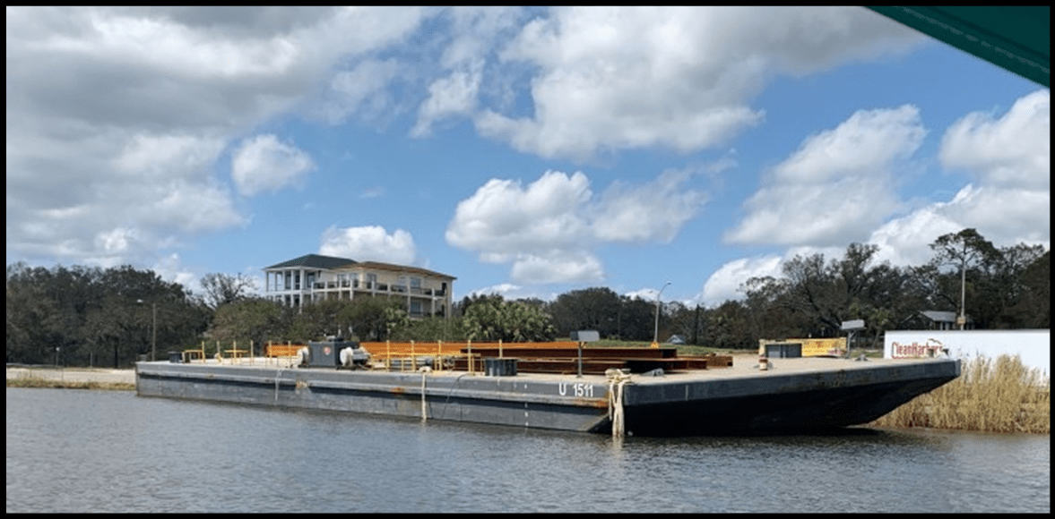
The following day, I made it back to Pensacola and saw several barges beached along Bayfront Parkway. I correctly surmised that those barges were from the Bay Bridge’s construction. Because several were grounded in the same general location, I hypothesized that the barges’ moorings must have been of similar strength. Since we know that Sally’s wind and surge directions shifted during the storm and since the barges were grouped together, they would have had to have snapped their moorings at similar times, with similar wind and water forces acting on them. If they had been freed at different times, they should not be located near each other.
I surmised that experienced mariners would anchor their vessels in an efficient and consistent enough manner that anchor lines, even from different size vessels, would have similar storm resistance. Otherwise, crews would be wasting time and money over-mooring vessels or worse, under-mooring them. From an engineering and physics standpoint, a simultaneous freeing of the barges made sense to me too. After all, anchor lines have a finite strength, but wind and water forces increase exponentially with the velocity. In other words, if the speed of wind or water doubles, the force it imparts quadruples. I therefore surmised that at some point during the storm, wind and water forces were high enough that an added gust or large wave suddenly and exponentially increased the force on many barges simultaneously, snapping all of their anchor lines in a relatively short period.
I knew that a simultaneous freeing and clustering of groundings could have archeological importance, particularly with respect to the Luna Colony. The Luna Fleet, consisting of at least 12 ships, arrived to Pensacola Bay on August 14, 1559. Before the ships were unloaded, a powerful hurricane struck. According to Priestley:
“It is that on Monday, during the night of the nineteenth of this month of September, there came up from the north a fierce tempest, which, blowing for twenty-four hours from all directions until the same hour as it began, without stopping but increasing continuously, did irreparable damage to the ships of the fleet. [There was] great loss by many seamen and passengers, both of their lives as well as of their property. All the ships which were in this port went aground (although it is one of the best ports there are in these Indies), save only one caravel and two barks, which escaped.”
Three of Luna’s ships previously found off of Emanuel Point seemed to support my hypothesis. With no other documented ships lost from the fleet other than those grounded in the 1559 Hurricane, these ships assuredly were two of the seven that broke free during the 1559 hurricane. There is no evidence that the Emanuel Point wrecks were moored. For one, the water is too shallow to be a reasonable anchorage. Additionally, the only anchor found at the wreck sites was one lashed to the gunnels of the ship. My hypothesis would therefore support that other lost ships of the fleet could be found near those wrecks.
Not only would finding more of Luna’s ships be an archeological treasure-trove, by proving my hypothesis, it might open the door for the possibility of modeling to backtrack from Emanuel Point to the possible mooring locations of Luna’s fleet. Since the fleet is documented as being just offshore of the colony. Finding the mooring of the Luna Fleet would dramatically reduce the search area for Luna Colony itself.
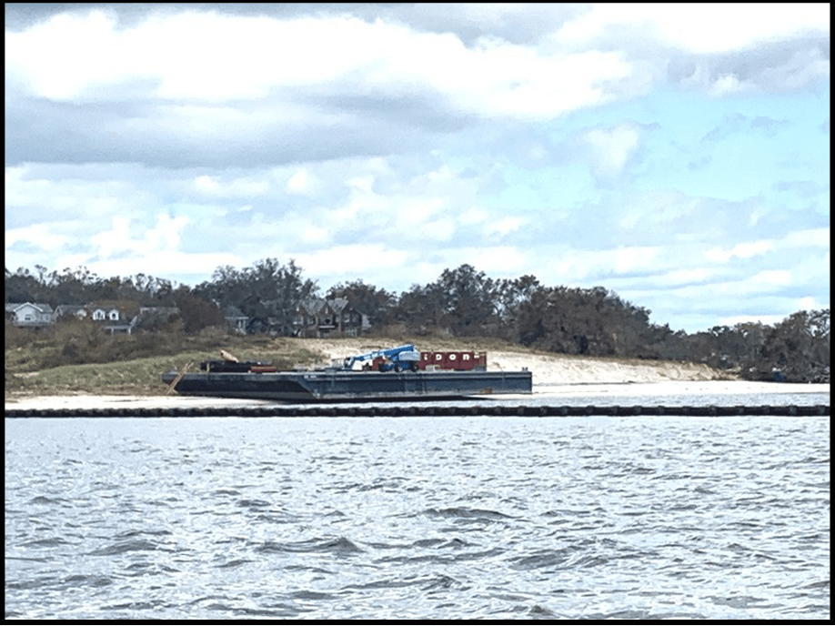
For me, working in Pensacola and living in Gulf Breeze, Sally’s closure of the Bay Bridge meant a commute over I-10’s Escambia Bridge and down the Garcon Bridge. A few days after the storm, driving home over the I-10 bridge, I noticed a large barge with a big red crane grounded on the Garcon peninsula. At the time, it didn’t click with me that it was out of place. Later, it was confirmed that this barge was from the Bay Bridge construction site.
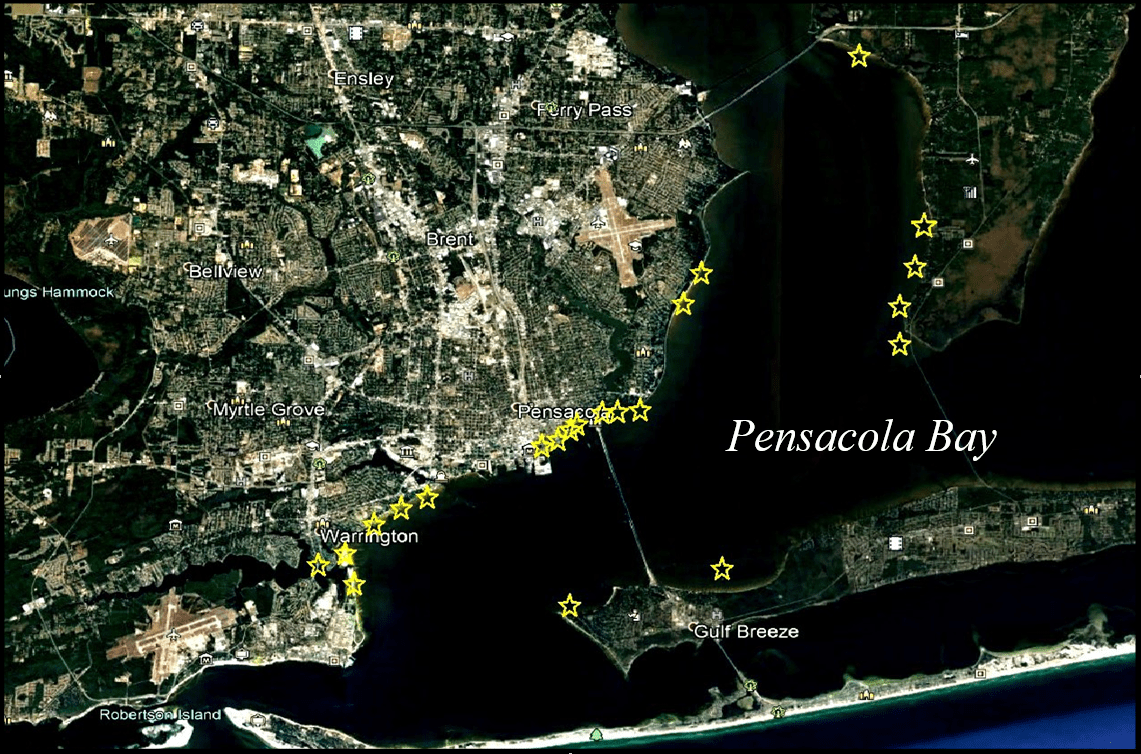
During the coming days, I learned of more and more barge sightings that were too far out of place to match my hypothesis. Several days after the storm, NOAA published a high definition post-hurricane aerial of the bay. Scanning through the fresh aerial, the giant barges were easy to spot. In all, at least 22 construction barges snapped their moorings and floated free. Several barges struck our new bridge’s east span, severely damaging it. They bashed docks, seawalls, railroads and other area bridges. Two construction barges even traveled into bayous. What surprised me more than the distance some barges traveled was how they scattered. Barges, in no discernable pattern, went aground north, south, east and west of their mooring.
With real-world data as clear as this, my hypothesis immediately crumbled. The wind and water direction in hurricanes, particularly near its eye, change strength and direction, sometimes dramatically. Storms such as Sally are chaotic events. Based largely on our experience with Sally, it’s clear that the remnants of Luna’s fleet could be anywhere in the bay and should more wrecks be found, there’s no apparent way to use their location to help identify the fleet’s original mooring.


Related Documents
Bratten, John R.
1995 Olive Pits, Rat Bones, and Leather Shoe Soles: A Preliminary Report on the Organic Remains from the Emanuel Point Shipwreck, Pensacola, Florida. Underwater Archaeology Proceedings from the Society for Archeology. Washington, D.C.
Childers, Wayne and David Dodson
2005 Excerpts from Davila Padilla, Chapter 51-71, The Florida Expeditions. Unpublished manuscript.
Curren, Caleb
1994 The Search for Santa Maria, A 1559 Spanish Colony on the Northern Florida Coast.
Pensacola Archeology Lab.
Merrill, William L.
2018 The Water Problem: The Luna Colony and More. Archeology Ink. An On-Line Research Journal.
Priestley, Herbert Ingram
1928 The Luna Papers. Two Volumes. Florida State Historical Society. Deland, Florida.
1936 Tristan de Luna, Conquistador of the Old South: A Study of Spanish Imperial Strategy. The Arthur H. Clark Company, Glendale, California.
Smith, Roger C.
1994 The Emanuel Point Ship: An Examination of Florida’s Earliest Shipwreck. Underwater Archaeology Proceedings for the Society for Historical Archaeology Conference 1994:14-18. Vancouver, British Columbia.
1995 The Emanuel Point Ship: A Florida Experiment in Research, Development, and Management. Underwater Archaeology Proceedings from the Society for Historical Archaeology Conference 1995:40-42.
Smith, Roger C., James Spirek, John Bratten, and Della Scott-Ireton
1995 The Emanuel Point Ship: Archaeological Investigations, 1992-1995. Bureau of Archaeological Research, Division of Historical Resources, Florida Department of State.
- Article
-
Abstract
The goal of this article is to shed light on the question of the location of the anchorage and location of the shipwrecks of the 1559 Luna Fleet and Colony on Pensacola Bay. A hurricane hit the Luna Fleet in September of 1559 and scattered the fleet. Seven ships were sunk. In September of 2020, 461 years after the Luna Fleet destruction, another hurricane struck Pensacola Bay creating devastation. Large construction barges (22) anchored in the bay broke loose from their moorings and were beached in Pensacola Bay throughout a huge area. The conclusion is that the 1559 Luna Fleet was also scattered throughout the bay and just because a Luna period shipwreck is found does not indicate the location of the fleet nor does it indicate the location of the Luna Colony.

Barge Driven Ashore By Hurricane Sally On the morning of September 15th, 2020 Hurricane Sally was predicted to come ashore along the Mississippi-Alabama border, making landfall as a category one storm or even as a downgraded tropical storm. I headed into work from Gulf Breeze to Pensacola over the new Chappie James Bay Bridge’s east span. The west span, still under construction, was lined with barges, tug-boats, cranes and large equipment. Heavy rain and steady wind mixed with gusts jostled my truck as I approached the high point of the bridge. White-capped swells in the bay looked more like something that should’ve been in the Atlantic Ocean. A tug-boat off to my right rocked back and forth as it struggled to secure a barge. Its cabin lights were on and I could see the intense focus of the crew from their mannerisms.
By early that afternoon, one barge had struck the new bridge, forcing it to be closed. Later that night and into the following morning, Sally intensified and turned our way. Sally was very slow moving and churned over our area for almost two days, increasing continuously until the morning of September 16th.
The following day, I made it back to Pensacola and saw several barges beached along Bayfront Parkway. I correctly surmised that those barges were from the Bay Bridge’s construction. Because several were grounded in the same general location, I hypothesized that the barges’ moorings must have been of similar strength. Since we know that Sally’s wind and surge directions shifted during the storm and since the barges were grouped together, they would have had to have snapped their moorings at similar times, with similar wind and water forces acting on them. If they had been freed at different times, they should not be located near each other.
I surmised that experienced mariners would anchor their vessels in an efficient and consistent enough manner that anchor lines, even from different size vessels, would have similar storm resistance. Otherwise, crews would be wasting time and money over-mooring vessels or worse, under-mooring them. From an engineering and physics standpoint, a simultaneous freeing of the barges made sense to me too. After all, anchor lines have a finite strength, but wind and water forces increase exponentially with the velocity. In other words, if the speed of wind or water doubles, the force it imparts quadruples. I therefore surmised that at some point during the storm, wind and water forces were high enough that an added gust or large wave suddenly and exponentially increased the force on many barges simultaneously, snapping all of their anchor lines in a relatively short period.
I knew that a simultaneous freeing and clustering of groundings could have archeological importance, particularly with respect to the Luna Colony. The Luna Fleet, consisting of at least 12 ships, arrived to Pensacola Bay on August 14, 1559. Before the ships were unloaded, a powerful hurricane struck. According to Priestley:
“It is that on Monday, during the night of the nineteenth of this month of September, there came up from the north a fierce tempest, which, blowing for twenty-four hours from all directions until the same hour as it began, without stopping but increasing continuously, did irreparable damage to the ships of the fleet. [There was] great loss by many seamen and passengers, both of their lives as well as of their property. All the ships which were in this port went aground (although it is one of the best ports there are in these Indies), save only one caravel and two barks, which escaped.”
Three of Luna’s ships previously found off of Emanuel Point seemed to support my hypothesis. With no other documented ships lost from the fleet other than those grounded in the 1559 Hurricane, these ships assuredly were two of the seven that broke free during the 1559 hurricane. There is no evidence that the Emanuel Point wrecks were moored. For one, the water is too shallow to be a reasonable anchorage. Additionally, the only anchor found at the wreck sites was one lashed to the gunnels of the ship. My hypothesis would therefore support that other lost ships of the fleet could be found near those wrecks.
Not only would finding more of Luna’s ships be an archeological treasure-trove, by proving my hypothesis, it might open the door for the possibility of modeling to backtrack from Emanuel Point to the possible mooring locations of Luna’s fleet. Since the fleet is documented as being just offshore of the colony. Finding the mooring of the Luna Fleet would dramatically reduce the search area for Luna Colony itself.
For me, working in Pensacola and living in Gulf Breeze, Sally’s closure of the Bay Bridge meant a commute over I-10’s Escambia Bridge and down the Garcon Bridge. A few days after the storm, driving home over the I-10 bridge, I noticed a large barge with a big red crane grounded on the Garcon peninsula. At the time, it didn’t click with me that it was out of place. Later, it was confirmed that this barge was from the Bay Bridge construction site.
During the coming days, I learned of more and more barge sightings that were too far out of place to match my hypothesis. Several days after the storm, NOAA published a high definition post-hurricane aerial of the bay. Scanning through the fresh aerial, the giant barges were easy to spot. In all, at least 22 construction barges snapped their moorings and floated free. Several barges struck our new bridge’s east span, severely damaging it. They bashed docks, seawalls, railroads and other area bridges. Two construction barges even traveled into bayous. What surprised me more than the distance some barges traveled was how they scattered. Barges, in no discernable pattern, went aground north, south, east and west of their mooring.
With real-world data as clear as this, my hypothesis immediately crumbled. The wind and water direction in hurricanes, particularly near its eye, change strength and direction, sometimes dramatically. Storms such as Sally are chaotic events. Based largely on our experience with Sally, it’s clear that the remnants of Luna’s fleet could be anywhere in the bay and should more wrecks be found, there’s no apparent way to use their location to help identify the fleet’s original mooring.

Yellow Stars = Barges 
Barge Driven Ashore By Hurricane Sally - Related Documents
-
Related Documents
Bratten, John R.
1995 Olive Pits, Rat Bones, and Leather Shoe Soles: A Preliminary Report on the Organic Remains from the Emanuel Point Shipwreck, Pensacola, Florida. Underwater Archaeology Proceedings from the Society for Archeology. Washington, D.C.Childers, Wayne and David Dodson
2005 Excerpts from Davila Padilla, Chapter 51-71, The Florida Expeditions. Unpublished manuscript.Curren, Caleb
1994 The Search for Santa Maria, A 1559 Spanish Colony on the Northern Florida Coast.
Pensacola Archeology Lab.Merrill, William L.
2018 The Water Problem: The Luna Colony and More. Archeology Ink. An On-Line Research Journal.Priestley, Herbert Ingram
1928 The Luna Papers. Two Volumes. Florida State Historical Society. Deland, Florida.1936 Tristan de Luna, Conquistador of the Old South: A Study of Spanish Imperial Strategy. The Arthur H. Clark Company, Glendale, California.
Smith, Roger C.
1994 The Emanuel Point Ship: An Examination of Florida’s Earliest Shipwreck. Underwater Archaeology Proceedings for the Society for Historical Archaeology Conference 1994:14-18. Vancouver, British Columbia.1995 The Emanuel Point Ship: A Florida Experiment in Research, Development, and Management. Underwater Archaeology Proceedings from the Society for Historical Archaeology Conference 1995:40-42.
Smith, Roger C., James Spirek, John Bratten, and Della Scott-Ireton
1995 The Emanuel Point Ship: Archaeological Investigations, 1992-1995. Bureau of Archaeological Research, Division of Historical Resources, Florida Department of State. - Download PDF Version