The Mystery of the Tabby Structure on Mobile Bay
by:
Caleb Curren
and
David Dodson
(Contact Archeology Inc.)
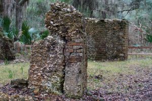
Nicholas Cook, a Frenchman, came to the Bon Secour River in the late 1790s and bought property to settle in southern Baldwin County. On his property he found walls of a very old building. The building, mostly fallen down, was made of a concrete-like substance known as “tabby.” The building measured approximately 16 feet by 32 feet. Cook had no idea who had built it. It became a local legend and subject to much speculation.
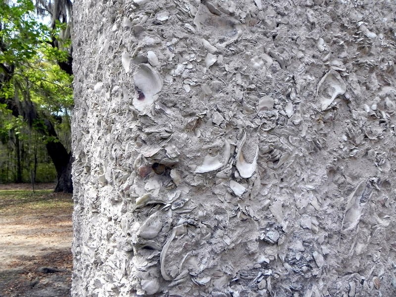
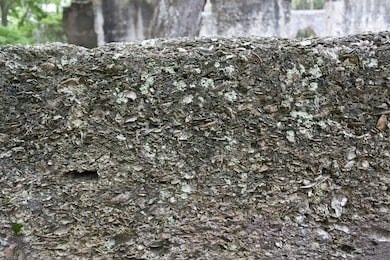
Tabby was comprised of lime, sand, shells, ash, and freshwater. Tabby was used in the current Southeast along coastlines by the early Spanish of the 1500s, including among others St. Augustine and Mound Island in Estero Bay, both in Florida. Tabby structures are very durable and last for centuries.
Excavations were conducted at the Bon Secour site (1Ba53) starting in November of 1964 and continued into the early summer of 1965 led by David M. White, then an archeology student at Florida State University. Quoting White:
“The construction method is typically Spanish. Artifacts found during the excavations included both French and Spanish material. French faience, Spanish majolica, and other glazed earthenware, as well as musket balls, gun flints, and various iron hardware were included. Wrought iron nails used before 1750 were numerous.”
These facts are very revealing. The gunflints certainly postdate the Luna Expedition. The pre-1750 iron nails are interesting as well. The French Faience and Spanish Majolica pottery from the site were tin-glazed earthenware types that were first introduced during the 1500s. The statement that: “The construction method is typically Spanish” is also telling. The primary occupation in the 1700s in Mobile Bay was French, not Spanish. The only occupation of Mobile Bay in the 1500s was Spanish.
White concluded that the site was evidence of a French presence in the 1700s and he may well be correct. Our goal is to examine the possibility that the tabby structure could possibly be evidence of the Luna Expedition of 1559-1560 into Mobile Bay which they referred to as Bahia Filipina in honor of the Spanish King Philip II.
The site is located in an excellent area for settlement. It was near the entrance to Mobile Bay and had an adequate supply of freshwater. That said, it was a convenient spot for a campsite on the inland water route along the eastern side of the extensive bay. The question is whether the French of the 1700s and/or the Spanish of the 1500s took advantage of the site location.
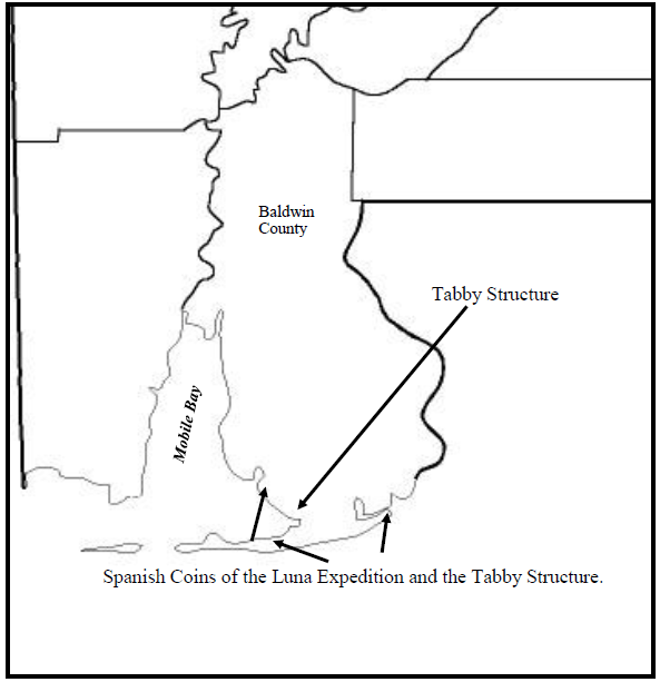
Artifacts from the region come into the issue. Three artifacts, known as Charles and Johanna coins, dating to the Luna Expedition period, have been found in the general vicinity of the tabby structure. The locations are at the Bear Point Site (1Ba1), The Strongs Bayou Site (1Ba81), and the Dorgans Landing Site (1Ba208). Did the Spaniards of the Luna Expedition build an outpost on the Bon Secour River to protect their interests? Did they trade with the Natives? Are the Spanish coins evidence of this trade?
So how can we test this hypothesis? We locate the artifacts found from the White excavations to scrutinize their origins and time periods. We find the technical report of his work. We are working on that. We will report later on our findings. The following pages are comprised of images and references.
Images of tabby wall construction.
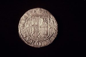
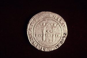
Three artifacts, known as Charles and Johanna coins, dating to the Luna Expedition period have been found in the general vicinity of the tabby structure. The locations are at the Bear Point Site (1Ba1), The Strongs Bayou Site 1Ba81), and the Dorgans Landing Site (1Ba208). The figure above is the Spanish coin found in a Native burial on the Bear Point Peninsula (1Ba1). We found the coin in the Smithsonian collections.
The views here are of the obverse and reverse sides of the coin. The coin is 27 mm in diameter, a little larger than a U.S. quarter and hand cut from a sheet of silver. This and the other two coins were hand stamped on both sides. On one side is the Spanish crest of the ruling families of the Province of Castile, represented by a castle, and the Province of Leon, represented by a lion. It signifies that Spain was united by a wedding.
Around the perimeter of one side of the coins reads in Latin, “Carlos et Iohana Reges,” referring to the king and queen of Spain at the time and translates to “Carlos and Johanna Rule.”
There also is a letter “L” on the coins, which identifies the mark of assayer of the Mexico City mint, Luis Rodríguez. He was the official assayer from A.D. 1554-1570.
On one side of the coin is a depiction of the Pillars of Hercules. These are mammoth rock formations in southern Spain at the mouth of the Mediterranean Sea in the straits of Gibraltar. Beneath the image are the Latin words “Plus Ultra” translated as “More Beyond.”
Between the pillars are two dots that represent the denomination of the coin, two reales. Around the perimeter of the coin is another Latin inscription, “Hispariarum et Indiarum” translated to Spain and the Indies.
The whole message on the coins is that Spain ruled the “New World” at the time.
Related Works
Comings, J. Newcomb Comings and Martha M. Albers
1928 A Brief History of Baldwin County. Baldwin County Historical Society.
Nesmith, Robert
1977 The Coinage of the First Mint of the Americas at Mexico City.
Quarterman Publications Inc. Lawrence, Massachusetts.
Nuzum, Kay
1971 A History of Baldwin County. Eastern Shore Publishing Company.
Sickels, Lauren and Michael S. Sheehan
1999 The Lost Art of Tabby: Preserving Oglethorpe’s Architectural Legacy.
Architectural Conservation Press.
White, David M.
1965 The Mystery Fort at Bon Secour. (rootsweb.com/-alcbonse/fort.html)
- Article
-
Nicholas Cook, a Frenchman, came to the Bon Secour River in the late 1790s and bought property to settle in southern Baldwin County. On his property he found walls of a very old building. The building, mostly fallen down, was made of a concrete-like substance known as “tabby.” The building measured approximately 16 feet by 32 feet. Cook had no idea who had built it. It became a local legend and subject to much speculation.
Tabby was comprised of lime, sand, shells, ash, and freshwater. Tabby was used in the current Southeast along coastlines by the early Spanish of the 1500s, including among others St. Augustine and Mound Island in Estero Bay, both in Florida. Tabby structures are very durable and last for centuries.
Excavations were conducted at the Bon Secour site (1Ba53) starting in November of 1964 and continued into the early summer of 1965 led by David M. White, then an archeology student at Florida State University. Quoting White:
“The construction method is typically Spanish. Artifacts found during the excavations included both French and Spanish material. French faience, Spanish majolica, and other glazed earthenware, as well as musket balls, gun flints, and various iron hardware were included. Wrought iron nails used before 1750 were numerous.”
These facts are very revealing. The gunflints certainly postdate the Luna Expedition. The pre-1750 iron nails are interesting as well. The French Faience and Spanish Majolica pottery from the site were tin-glazed earthenware types that were first introduced during the 1500s. The statement that: “The construction method is typically Spanish” is also telling. The primary occupation in the 1700s in Mobile Bay was French, not Spanish. The only occupation of Mobile Bay in the 1500s was Spanish.
White concluded that the site was evidence of a French presence in the 1700s and he may well be correct. Our goal is to examine the possibility that the tabby structure could possibly be evidence of the Luna Expedition of 1559-1560 into Mobile Bay which they referred to as Bahia Filipina in honor of the Spanish King Philip II.
The site is located in an excellent area for settlement. It was near the entrance to Mobile Bay and had an adequate supply of freshwater. That said, it was a convenient spot for a campsite on the inland water route along the eastern side of the extensive bay. The question is whether the French of the 1700s and/or the Spanish of the 1500s took advantage of the site location.
Artifacts from the region come into the issue. Three artifacts, known as Charles and Johanna coins, dating to the Luna Expedition period, have been found in the general vicinity of the tabby structure. The locations are at the Bear Point Site (1Ba1), The Strongs Bayou Site (1Ba81), and the Dorgans Landing Site (1Ba208). Did the Spaniards of the Luna Expedition build an outpost on the Bon Secour River to protect their interests? Did they trade with the Natives? Are the Spanish coins evidence of this trade?
So how can we test this hypothesis? We locate the artifacts found from the White excavations to scrutinize their origins and time periods. We find the technical report of his work. We are working on that. We will report later on our findings. The following pages are comprised of images and references.
Images of tabby wall construction.


Three artifacts, known as Charles and Johanna coins, dating to the Luna Expedition period have been found in the general vicinity of the tabby structure. The locations are at the Bear Point Site (1Ba1), The Strongs Bayou Site 1Ba81), and the Dorgans Landing Site (1Ba208). The figure above is the Spanish coin found in a Native burial on the Bear Point Peninsula (1Ba1). We found the coin in the Smithsonian collections.
The views here are of the obverse and reverse sides of the coin. The coin is 27 mm in diameter, a little larger than a U.S. quarter and hand cut from a sheet of silver. This and the other two coins were hand stamped on both sides. On one side is the Spanish crest of the ruling families of the Province of Castile, represented by a castle, and the Province of Leon, represented by a lion. It signifies that Spain was united by a wedding.
Around the perimeter of one side of the coins reads in Latin, “Carlos et Iohana Reges,” referring to the king and queen of Spain at the time and translates to “Carlos and Johanna Rule.”
There also is a letter “L” on the coins, which identifies the mark of assayer of the Mexico City mint, Luis Rodríguez. He was the official assayer from A.D. 1554-1570.
On one side of the coin is a depiction of the Pillars of Hercules. These are mammoth rock formations in southern Spain at the mouth of the Mediterranean Sea in the straits of Gibraltar. Beneath the image are the Latin words “Plus Ultra” translated as “More Beyond.”
Between the pillars are two dots that represent the denomination of the coin, two reales. Around the perimeter of the coin is another Latin inscription, “Hispariarum et Indiarum” translated to Spain and the Indies.
The whole message on the coins is that Spain ruled the “New World” at the time.

- References and Related Works
-
Related Works
Comings, J. Newcomb Comings and Martha M. Albers
1928 A Brief History of Baldwin County. Baldwin County Historical Society.Nesmith, Robert
1977 The Coinage of the First Mint of the Americas at Mexico City.
Quarterman Publications Inc. Lawrence, Massachusetts.Nuzum, Kay
1971 A History of Baldwin County. Eastern Shore Publishing Company.Sickels, Lauren and Michael S. Sheehan
1999 The Lost Art of Tabby: Preserving Oglethorpe’s Architectural Legacy.
Architectural Conservation Press.White, David M.
1965 The Mystery Fort at Bon Secour. (rootsweb.com/-alcbonse/fort.html) - Download PDF Version